-
White storks make strong return in France via nest ‘platforms’ and clipped wings
The Ligue pour la Protection des Oiseaux shares the conservation challenges in saving these birds from extinction
-
Hosting scheme in south-west France lets newcomers sample lifestyle
Households in nine Dordogne communes volunteer under Mes Nouveaux Voisins scheme
-
French boulangeries demand right for staff to work on May 1 so they can open
Artisan bakery owners can work but employees cannot, while certain industrial bakeries are allowed to remain open with workers
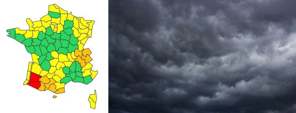
Heavy rain, floods, snow, ice: 11 French departments on orange alert
Areas of the southwest and in the east are particularly affected by exceptionally heavy downpours

[Update December 10 at 14:20 - The alert level for high river levels and flooding has now been upgraded to red in Pyrénées-Atlantique and Landes]
Eleven French departments are under orange weather alerts this morning (December 10), as heavy rain and localised snowfall cause disruption across parts of southwestern and eastern France.
🔴2 dpts #vigilanceRouge
— Météo-France (@meteofrance) December 10, 2021
🟠9 dpts et Andorre #vigilanceOrange
🌧️Épisode de #pluies marquées sur #Pyrénées.#Crues importantes en cours #SudOuest en particulier sur Gaves réunis.
❄️🏔️Fortes chutes de #neige, nord #Alpes.
Très fort risque #avalanches, Pyrénées et Alpes du Nord. pic.twitter.com/zeD6hhSK0v
Heavy rain and flooding
Pyrénées-Atlantiques and Haute-Pyrénées continue under the orange warning for heavy rain under which they were placed yesterday (December 9), and are now joined by Haute-Garonne and Ariège.
Read more: Man saved in ‘miracle’ rescue amid floods in southwest France
Yesterday’s rainfall, which Météo France describes as being “remarkable in its duration and the quantity expected [to fall],” has gradually moved eastwards overnight, turning to snow above certain altitudes.
In areas of Pyrénées-Atlantiques, 70 to 100mm of rain fell in the 12 hours to 05:00, with 129mm coming down over Laruns to the south of Pau.
In Laruns-Artouste, higher in the mountains, 136mm had fallen, a significant quantity considering 176mm would normally be expected over a whole month.
The rain in Haute-Garonne and Ariège has not reached the same intensity, with 30-50mm falling overnight. However, downfalls are forecast to continue throughout the day and into tomorrow (December 11).
Today, 30-60mm is expected on lower ground, with 70-100mm in the Pyrenean foothills and 130-150mm in the mountains.
The rainfall will be accompanied by strong northwesterly winds reaching 60-90km/h on lower ground and 120-130km/h in the mountains.
In addition, a long, northwesterly swell along the Basque coastline may prevent rivers from flowing into the sea and aggravate any flooding which may occur.
Pyrénées-Atlantiques, Hautes-Pyrénées, Gers and Landes are also under an orange alert for high river levels and potential flooding, and you can follow the situation in these departments through government information service Vigicrues.
These weather warnings will last throughout the day and into tomorrow morning.
Snow and black ice
Ain, Haute-Savoie and Savoie are all under an orange alert for snow and black ice, which will last until the early afternoon.
Up to 20cm of snow could fall over lower altitudes around the level of Bellegarde-sur-Valserine (Ain) and Albertville (Savoie) this morning. In the mountains, snowfall could reach 30-40cm.
Any precipitation will take the form of snow after 600-800m above sea level from this afternoon.
This heavy snowfall could affect road networks and other infrastructures.
Pyrénées-Atlantiques, Hautes-Pyrénées, Haute-Garonne, Ariège, Pyrénées-Orientales, Isère, Savoie and Haute-Savoie are also under an orange alert for avalanches, caused by the infiltration of rainwater into snow slabs.
The risk of avalanches will diminish in the Pyrenees over the course of the morning, as the rain abates and the temperature drops. However, for now it remains ‘very high’ (level 5) on the Aspe-Ossau, Haute-Bigorre, Luchonnais, Couserans, Haute-Ariège and Andorran massifs.
In the Alps, the risk of avalanches will increase over the morning as rain and snowfall continues. Avalanche activity will drop over the afternoon and evening.
What precautions should be taken?
In areas where heavy rain and flooding is expected, residents may be affected by road, rail and electricity supply disruption.
People should stay away from bodies of water and avoid driving down a road which is even partially flooded. If possible, they should not go down into cellars or basements and should move ground-floor possessions upstairs.
In the case of heavy snowfall, people should limit car journeys, and make sure that their vehicle is fitted with the correct winter equipment if they must go out.
In areas where avalanches are likely, you should not go out in the mountains and should keep up to date with alerts issued by the authorities.
Related stories
Truffle season starts in France with quantity down but quality up
Saint-Nectaire cheese shortage in France due to bad weather conditions


