-
Miss France: glam - but not sexy
Miss France organiser Geneviève de Fontenay fears she is fighting a losing battle to protect her 'Cinderella dream' from vulgarity
-
Normandy Landings visit for Queen
Queen Elizabeth has confirmed a state visit to France, ending rumours she is handing over duties to Charles
-
Health warning on cold remedies
Consumer group says many over-the-counter remedies have side-effects that are ‘too large a risk for a simple cold’
GR, GRP, PR: What do the French hiking signs mean?
What are the coloured symbols on French hiking routes? Who paints them there and why?

When walking in the countryside, for a Sunday stroll or a serious hike, you should follow a legal right of way.
Both publicly and privately owned tracks may include legal footpaths, developed through formal agreements with landowners or by tradition through term use.
Each departmental council has an official local footpaths and hiking routes plan (PDIPR) showing all recognised paths. However, as this is not available to the general public, the simplest way to make sure you are walking on one of them is to follow routes designated by one of three national footpath categories.
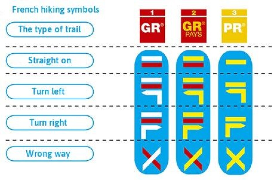
These have often been marked with a colour-code by volunteer baliseurs (markers) from the Fédération Française de la Randonnée Pédestre (FFRP), the national walkers’ body. In each case, a plain mark indicates you are on the right route; one with an arrow pointing left or right tells you to change direction; and a cross indicates not to continue that way.
Grande Randonnée (GR): a red and a white stripe. These footpaths were launched in 1947 and are organised by the FFRP. They are mostly one-way, long-distance walks, eg. the GR 20, which goes from the north to the south of Corsica or the GR10 that links the Mediterranean and Atlantic. The FFRP grew out of an committee of enthusiasts set up to launch the grande randonnée idea.
GR de Pays: a red and a yellow stripe. These are circular walks in an area with a certain local character and culture. They include the Ceinture Verte de l’Ile de France or the Tour du Morvan (a mountainous area in Burgundy).
Promenade et Randonée (PR): a yellow stripe. These are designed for a day’s walk or a few hours, worked out by departmental hiking committees affiliated to the FFRP.
Usually the markers are painted on to fixtures such as trees so they can be followed easily. To discover marked paths in your area, the FFRP publishes 180 “topoguide” guidebooks to walking in different parts of France, priced €8-15 (see www.ffrandonnee.fr and boutique).
FFRP adviser Claude Dache said: “They include maps and food and lodging suggestions and advice about what to expect, depending on the season. It’s preferable to follow a marked path.”
In some cases, however, footpaths may not be marked. To see all designated footpaths in your area, you could buy the local IGN map, published by the Institut Géographique National (the French equivalent of the Ordnance Survey).
In some areas, tourist offices also have free walk guides published by the departmental council, which may use a local marker scheme in parallel to the national ones.
Usually walking such official routes goes without a hitch, as legal rights issues have been settled with landowners. Occasionally, however, one of them decides to block off part of a route. The FFPR will undertake negotiations with the landowner and with parties such as the local mairie.
You can freely walk along country roads such as routes départementales or communales (though you must use a pavement if provided), but when it comes to some other minor roads and tracks the picture is less clear-cut:
Publicly owned routes
- Chemins ruraux: council-owned country tracks, used mainly for residents’ access or by farmers. They can usually be used by walkers, but, because the council has no obligation to maintain them, they may be in a poor state.
- Publicly owned chemins d’exploitation: tracks to access private council or state land are not accessible.
Privately owned
- Private owners are not obliged to allow walkers on their property, including roads for residents’ use, but may have agreed to.
Chemins forestiers
These are forest tracks that may be privately or state-owned and public access may either be allowed or denied (this will usually be signed).
Voies vertes
These “green ways” are tracks for all transport types apart from motor vehicles, including walkers. They may be rural or urban and may follow such routes as canal towpaths or disused railways. Find different ones around France at: www.voiesvertes.com
Walking by water
With certain exceptions, the public has the right to walk along most of the coastline. A right also exists to walk beside rivers, streams and lakes passing through publicly owned land.


