-
Travellers risk extra costs under new Eurotunnel ticket rule
Some fare options are less flexible and less forgiving of lateness
-
May will be difficult month for train travel in France, warns minister
Two major train unions are threatening to strike and are ‘not willing to negotiate’, he says
-
Larousse dictionary adds 150 new French words - which ones do you know?
The new words come from trends in sport, nature, leisure, food, medicine, and the rest of the French-speaking world
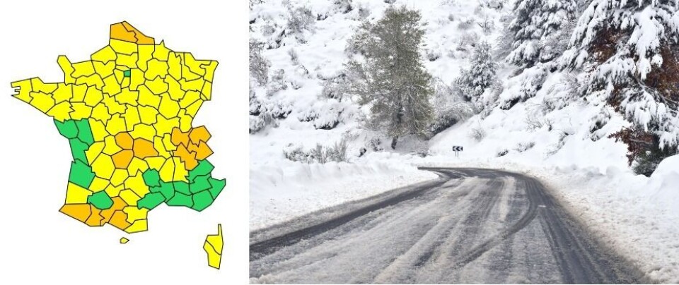
13 French departments on orange alert for floods, snow and black ice
The Massif Central, the Alps and the Pyrenees have all experienced significant snowfall overnight, increasing the risk of poor road conditions and avalanches

Météo France has placed 13 departments under orange weather alerts for localised flooding, snow, black ice and avalanches.
🔶 13 dpts en #vigilanceOrange
— VigiMétéoFrance (@VigiMeteoFrance) November 29, 2021
Restez informés sur https://t.co/rJ24zzmmy4 pic.twitter.com/B5ORS4jKfk
Flooding
People in Pas-de-Calais and Nord are being warned about high water levels and flooding, while the departments are also under a yellow weather alert for snow and black ice.
In the case of high water levels, people should avoid going near bodies of water, and should not drive down an even partially flooded road.
Snow, ice and avalanches
Read more: France puts 11 departments on orange alert for snow and ice
In central and eastern France, Puy-de-Dôme, Corrèze, Creuse, Ain, Savoie, Isère and Haute-Savoie are under an orange warning for snow – which began last night – and black ice.
In southwestern France, Pyrénées-Atlantiques, Hautes-Pyrénées, Haute-Garonne and Ariège have all been placed on an orange warning for snow and ice, while Pyrénées-Atlantiques and Hautes-Pyrénées are also on this level of alert for avalanches.
To the west of the Pyrenees more than one metre of snow has already fallen in mountainous areas, with 153cm coming down in Ardiden, which is at 2,445 metres above sea level.
Météo France has said that today’s snow forecast is not exceptional but “significant enough to create difficulties getting around and could disrupt certain activities.”
Overnight, several motorists found themselves stuck for up to seven hours on the A89 at Thiers (Puy-de-Dôme), where a 21-kilometre-long traffic jam had formed because of the snowfall.
Around 600 vehicles were evacuated between 22:00 and 01:00, and the road was closed until 06:00 this morning.
In areas such as Puy-de-Dôme, it is only snowing very lightly – if at all – now, but at altitudes above 500m temperatures are well below 0, leading to a refreezing of surface snow or water which could make roads slippery.
L'intensité des chutes de neige et le manque d'équipement de certains véhicules ont provoqué une perturbation majeure du trafic sur @A89Trafic. #VINCIAutoroutes et les forces de l'ordre mettent tout en œuvre pour permettre le passage des déneigeuses et rétablir la circulation. pic.twitter.com/WOPOelyntU
— VINCI Autoroutes (@VINCIAutoroutes) November 28, 2021
In the Alps, the precipitation continues, turning to snow above 200 or 300m. Although there is not a great volume expected to fall today, a weather alert remains in place because of potential disruption on the roads.
Local residents should avoid going out if possible, and if they must drive they should make sure that their car is fitted with appropriate winter equipment.
The risk of avalanches in Pyrénées-Atlantiques and Hautes-Pyrénées is “high” and Météo France warns that they could “threaten or reach exposed mountain infrastructures or roads, especially above 2,000.”
Lower areas are still likely to experience snow slips, but they are not expected to be as powerful as an avalanche.
In places where an avalanche warning is in place, people are encouraged not to go up into the mountains and to keep up to date with the safety instructions put in place by local authorities.
France’s national weather service has also put 65 departments around the country on yellow alerts, most commonly for snow and black ice.
The worst of the snowy weather should come to an end by around 15:00 today, while the high water levels could last into the early hours of tomorrow morning.
You can find out more about localised flood risk on the Vigicrues information service.
Related articles
Snow forecast across France this weekend as temperatures plummet
Bad weather means wine production down in France by a quarter


