-
Pension age reform in France: New poll shows support for a return to age 62
Employers' organisations and trade unions are currently meeting to discuss the subject on the orders of Prime Minister François Bayrou
-
Mystery of jewels found buried under communal wall in Dordogne
The gold rings, pearl brooches and diamond encrusted bracelets were discovered by a local association
-
Try a different way to cross UK-France the Channel - a sailing catamaran ferry
Passengers will be able to help sail the boat once out of the harbour
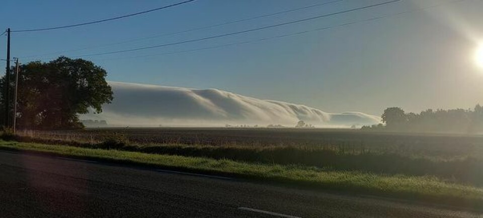
Rare cloud formation in central France likely to be a roll cloud
The Association Météo Centre has released photographs of the strange yet beautiful cloud formation taken on Saturday morning in Cher

A breathtaking cloud formation captured this weekend is very likely to be a roll cloud - an extremely rare phenomenon in France which is more usually seen in Australia or the US.
The photos were taken by members of the Association Météo Centre in Châteauneuf-sur-Cher on Saturday (October 23) morning and shared on the association’s social media accounts.
Roll clouds are one of two types of arcus clouds - low-level, horizontal cloud formations typically associated with thunderstorms. While the more common ‘shelf clouds’ are attached to the storm cloud, roll clouds are separated from it and often appear to be rolling about a horizontal axis.
Arcus clouds are caused by a downdraft (downward current of air) from an advancing storm, as explained by the UK Met Office:
‘When a cold downdraft... reaches the ground, the cold air may spread rapidly along the ground, pushing existing warm moist air upwards. As this air rises, water vapour condenses into the patterns associated with arcus clouds’.
Roll clouds, depending on conditions, ‘can last for several hours and extend for several hundred miles’, meteorologist at the National Oceanic and Atmospheric Administration (NOAA), Stephen Corfidi, told National Geographic.
They can sometimes be difficult to see if there is moisture in the air, for example during a thunderstorm, and especially when they are hidden behind other clouds.
Related articles
Public vote Cannes thunderstorm photo the best weather shot in world


