-
Britons are the largest foreign community of second-home owners in Nouvelle Aquitaine
See which other departments in the region are popular with British nationals
-
Travellers risk extra costs under new Eurotunnel ticket rule
Some fare options are less flexible and less forgiving of lateness
-
May will be difficult month for train travel in France, warns minister
Two major train unions are threatening to strike and are ‘not willing to negotiate’, he says
Seven French departments on orange alert for rain, floods, avalanches
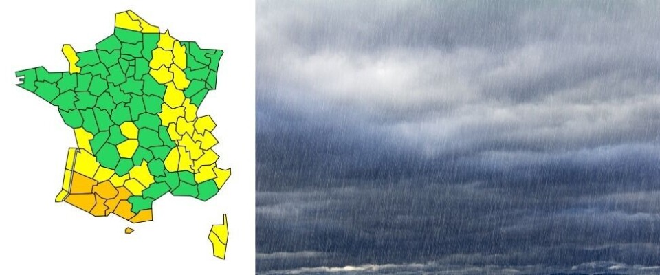
Pyrénées-Atlantiques, Hautes-Pyrénées, Gers, Landes, Haute-Garonne, Ariège and Pyrénées-Orientales are all under weather warnings set to last overnight and into tomorrow

Seven departments in southwestern France have been placed under orange weather alerts for heavy rain, flooding and avalanches.
Heavy rain and flooding
Pyrénées-Atlantiques and Hautes-Pyrénées had already been put on an orange warning for heavy rain and flooding from 15:00 this afternoon (December 9), but they have now both been moved to this level of alert for avalanches as well.
Read more:Alert for heavy rain and flooding in areas of southwest France
Gers and Landes are under an orange alert for high river levels and flooding. You can keep up to date with the situation in these areas by visiting public information service Vigicrues.
The rain falling over the Pyrenees this afternoon is described by government weather service Météo France as being “remarkable in their duration and the quantity [of water] expected.”
From this afternoon until lunchtime tomorrow, 50-70mm is expected to fall in the Basque country, 60-80mm in the foothills of the Pyrenees and 80-120mm in the Pyrenees.
Along the Basque country coastline a long, northwesterly swell is expected to hinder the flow of rivers into the sea and aggravate potential floods in the area.
Avalanches
Haute-Garonne, Ariège and Pyrénées-Orientales have been placed under an orange avalanche warning. Heavy rain and a rise in temperatures are making snowslides more likely, with the whole Pyrenees – apart from the Cerdagne-Canigou Massif – currently at risk level 4.
Towards the end of this afternoon, this risk level will rise to the maximum of 5 everywhere apart from Aure-Louron and Cerdagne-Canigou.
If avalanches do occur, the snow may block roads and disrupt mountain infrastructures. The risk level will decline tomorrow morning (December 10), as the rain abates and temperatures drop.
The avalanche activity expected to occur between this afternoon and tomorrow is normally only seen once every couple of years, and does not normally happen this early in the winter.
Do I need to do anything?
In areas under alerts for heavy rainfall, people should stay away from bodies of water and keep to higher ground or upstairs floors if possible.
They should not begin driving down a road that is even partially flooded.
In areas where an avalanche is likely, you should (obviously) not go out in the mountains and should keep up to date with alerts from the authorities.
Related stories
Saint-Nectaire cheese shortage in France due to bad weather conditions


