
-
Financial aid increases for communal EV charging points in France
The scheme will support at-home charging in communal car parks, which is cheaper than using public service stations
-
French far-right well ahead in new poll for 2027 presidential election
Jordan Bardella would face Edouard Philippe in second round, according to results but poll raises questions
-
French senators meet minister over retiree citizenship refusals
Concerns raised about 'overly tough' criteria being applied since last year's circular
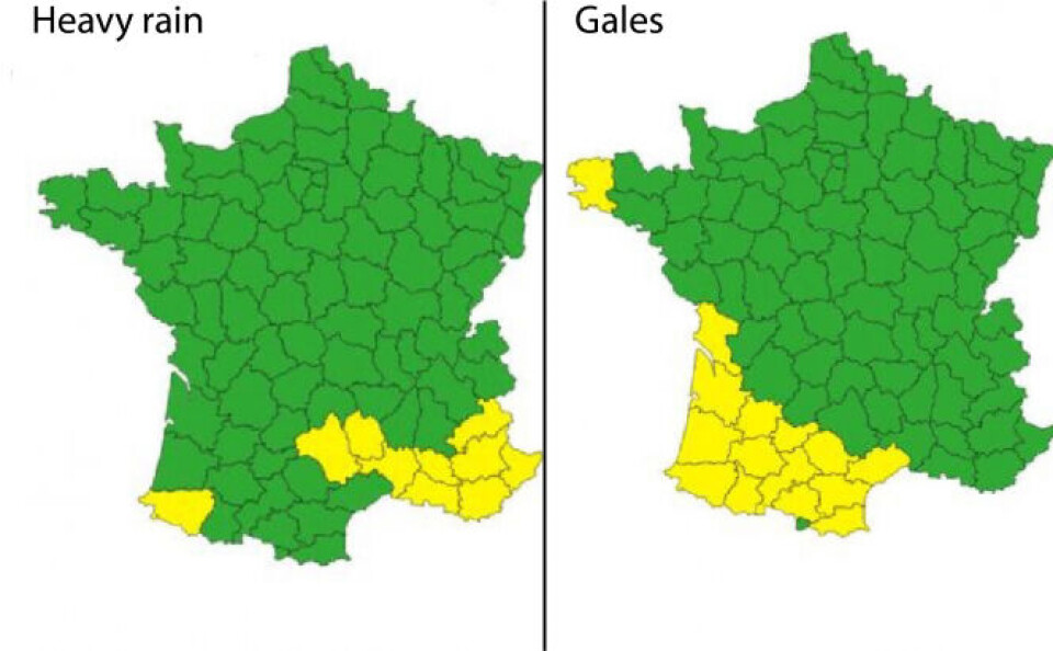
Weather warning: Half of all French departments on alert
The country braces for gales, rain and flooding

Weather alerts have been issued for half of the departments in mainland France as an ‘atmospheric river’ brings gales, rain and flooding to the country.
The French weather service Météo-France has placed 45 departments on (yellow) alert and two more on high (orange) alert for Saturday (February 10).
The ‘atmospheric river’ of warm and wet weather arriving from the Caribbean has brought a range of extreme weather with it, including gales in the south-west, an épisode méditerranéen in the south-east, coastal flooding along the Atlantic coast and bursting rivers in the north and north-east.
Anépisode méditerranéen in the south-east and gales in the south-west
Localised, violent Mediterranean storms, called an épisode méditerranéen, are forecast over the Alpes-Maritimes region, stretching into Occitanie as far as the Cévennes.
Heavy downpours should be expected as the storms reach their greatest intensity on Saturday morning.
Advertisement
The nature of an épisode méditerranéen is such that the storms can be particularly localised, and cause river flooding.
The departments on alert for heavy rain are: Alpes-Maritimes, Var, Bouches-du-Rhône, Gard, Alpes-de-Haute-Provence, Haute-Alpes, Vaucluse, Lozère, Aveyron and Pyrénées-Atlantiques.
Gales of up to 80km/h will buffet the south-west, with violent waves forecast all along the Atlantic coast from Spain, around Brittany and up to the Channel coast in Normandy.
The departments on alert for gales are: Hérault, Aude, Tarn, Ariège, Garonne, Tarn-et-Garonne, Lot-et-Garonne, Gers, Hautes-Pyrénées, Pyrénées-Atlantiques, Landes, Gironde, Charente-Maritime and Finistère.
Flooding in Pas-de-Calais and Finistère
The wave of wet weather is expected to worsen the situation in Pas-de-Calais, where the river Canche has already been flooded for a week.
In Finistère, the river Laïta has been subject to tidal flooding, which is exacerbated by the high winds.
The other departments on alert for potential flooding are: Vosges, Moselle, Meuse, Marne, Ardennes, Aisne, Nord, Oise, Seine-Maritime, Eure, Ille-et-Vilaine, Vendée, Deux-Sèvres, Charente-Maritime, Charente, Landes, Pyrénées-Atlantiques, Ardèche, Gard, Drôme, Vaucluse and Alpes-Maritimes.
An ‘atmospheric river’
The atmospheric event that brings a corridor of wet weather from the Caribbean is known in France as the ‘Rum Express’. A similar phenomenon that strikes California is known there as the ‘Pineapple Express’.
“The phenomenon is due to successive depressions over the Atlantic, which rotate simultaneously, acting like pumps, to send hot and wet air north,” states Météo-France.
The ‘Rum Express’ is expected to peak in intensity on Saturday morning and lose intensity by Sunday.
Read more
Alerts for heavy rain: forecasts worsen across France
Natural disaster declared in hundreds of communes in north of France


