-
Travellers risk extra costs under new Eurotunnel ticket rule
Some fare options are less flexible and less forgiving of lateness
-
May will be difficult month for train travel in France, warns minister
Two major train unions are threatening to strike and are ‘not willing to negotiate’, he says
-
New ski night train will link Paris to the French Alps
The Travelski Night Express will begin service this December and start selling tickets in May
How far can you get by train in five hours from near you in France?
You can see the maximum distance you can travel from any of Europe’s stations in one to five hours on a dedicated website – how does your local station do?

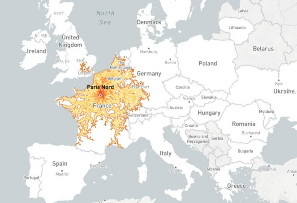
A website created by a French software developer allows you to see how far you can travel in under five hours from every train station in Europe.
It is called Chronotrains and was made by Benjamin Tran Dinh earlier this summer. See the map at this link here.
He has said that he was inspired by the German site Direkt Bahn Guru which, using a similar principle, displays all the cities that can be reached without changing trains from a given station, but with an indication of the minimum journey time.
Mr Tran Dinh used data from rail company Deutsche Bahn to create his map.
The map shows how far you can go in any direction from any train station in Europe in up to five hours, with one-hour journeys marked red and five-hour journeys marked light yellow, with the shades in between showing two-, three-, and four-hour journeys.
It is based on the supposition that train changes are no more than 20 minutes and that people can travel from one train station to another in the same city at an average speed of 9km/h.
“This map therefore represents an optimal version of these routes,” Mr Tran Dinh states on the website.
“Actual train schedules may vary from these estimates.”

Credit: Screenshot / Chronotrains
Read more: ‘French train travel is a joy compared to Germany’s awful rail system’
Disparities in rail links
Mr Tran Dinh told Le Figaro that making the map showed him the disparities in rail access between different European cities.
“It shows how some cities are isolated, how certain high-speed links are prioritised,” he said.
“It gives an idea of the development of the infrastructure in different regions.”
In a Tweet he highlighted Nice in the southeast of France as a city with very limited rail links compared to other places in Europe.
You can see the discrepancies in access to rail mobility between cities, how certain high-speed connections are favored, how certain cities are isolated... pic.twitter.com/KgZGJp38Ez
— Benjamin Td (@_benjamintd) July 29, 2022
Other cities are much better served. For example, with optimal timing you could get from Bordeaux in the west of France all the way to Saarbrücken in western Germany or up to Lille close to the Belgian border in around five hours.
Mr Tran Dinh already has plans to develop the website further by potentially removing the five-hour limit or adding a search tool to allow users to look for specific stations.
How good are the rail links in your local area? Let us know what you find out by using the map at news@connexionfrance.com
Related articles
Rail operators called to bid for Nantes-Lyon and Nantes-Bordeaux lines
French train station built by Mussolini looks to a brighter future
Can I take my bike on a trip across France using trains?


